Top 10 Marin County Waterfall Hikes
/Hurray for the rain. Nature has once again turned on the tap to the many amazing waterfalls around Marin County. It's great fun to soak up the many breathtaking waterfalls. I asked Ranger Mike from the Marin County Parks Department for his top 10 waterfall hikes.
Hi everyone, I’m Ranger Mike from Marin County Parks. With all the recent rain we have been getting, a lot of people are wondering where they can go to find some water free falling and in motion. Myself and Ranger Craig have come up with a list of some of the best spots in Marin County to enjoy some waterfalls and cascades.

Land Managing Agency: Marin Municipal Water District
Dog Regulations: Dogs on leash
Difficulty: 7 out of 10
Traffic: Heavy
Cataract Falls is probably one of the most well-known Waterfall hikes in Marin County. The trail follows Cataract Creek from 1,970 feet in elevation down to Alpine Lake at 650 feet in the length of 3 miles. It is accessible by road at both ends, although the northern trail head is an uphill hike the whole way. To get the best experience start at the Rock Springs trail head and hike north towards the falls. The trail here is mostly flat and crosses the flowing creek several times. At about 3/4 of a mile (just before the Ray Murphy Trail Bridge) you may notice an aircraft engine in the creek. This is an artifact of a midair collision between two US Navy F4U – Corsair’s a few months after World War 2 on October 4, 1945. After one mile you will reach Laurel Dell which has bathroom facilities and a picnic area. Continuing past the picnic area the trail starts to descend towards the falls. There are many cascades, but there are three main waterfalls. At the junction of Helen Markt Trail and Cataract Trail there is a descent sized pool that is a great spot to stop and rest.
* Note: Due to storm related damage the closest you can get is the trailhead on Ridgecrest that leads down to Laurel Dell. Unfortunately, it brings you to the Cataract trail above the waterfalls, and that trail is so much better from the bottom up. As a substitute for Cataract, try Steep Ravine (see #5 below.) A nice loop, and while not as dramatic, Steep Ravine is quite like Cataract.
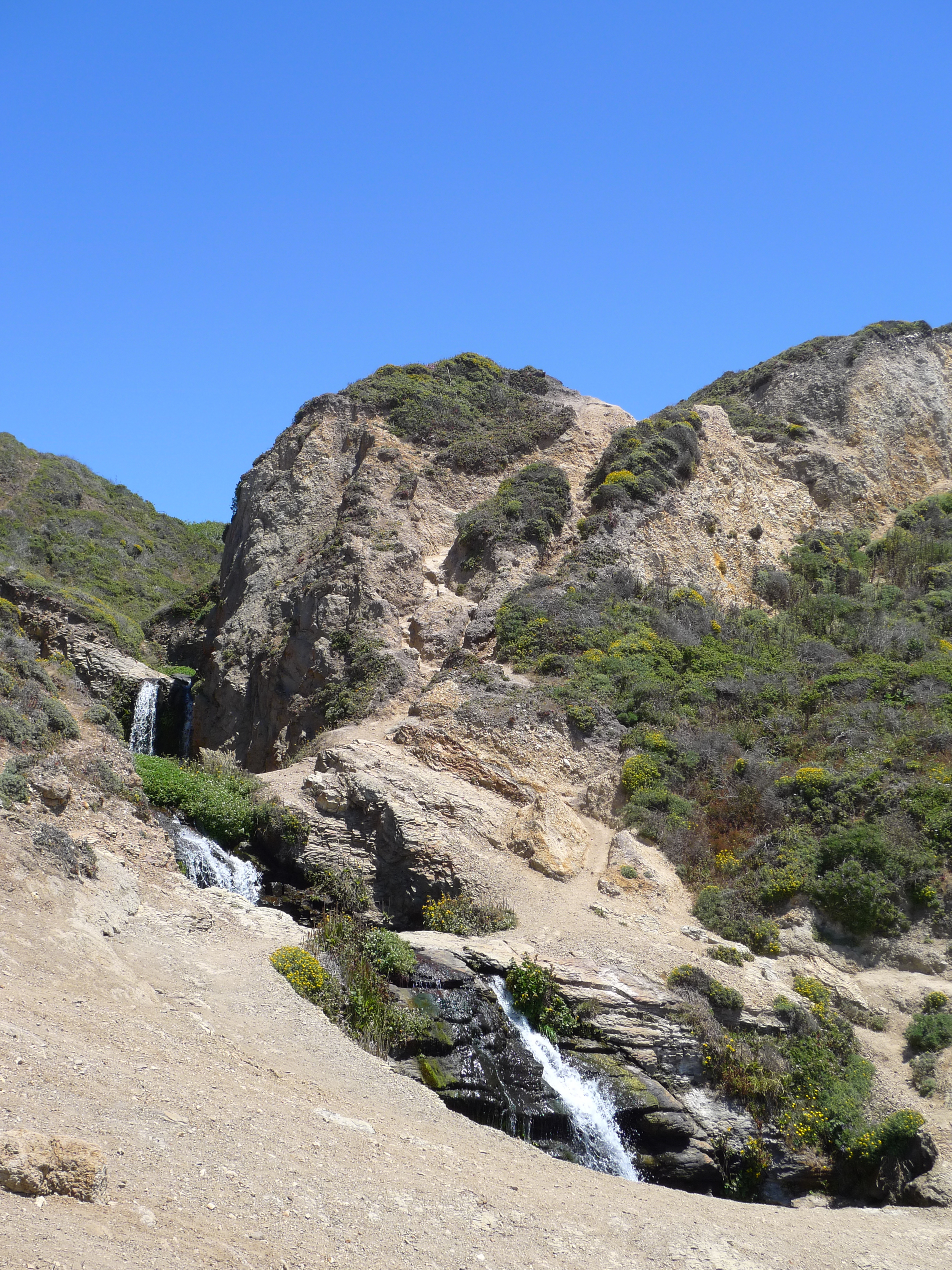
Photo by Ronnie Sharpe
Land Managing Agency: National Park Service: Point Reyes National Seashore
Dog Regulations: No Dogs
Difficulty: 6 out of 10
Traffic: Moderate
One of only two waterfalls in California that empty into the ocean, Alamere Falls is a pretty spectacular sight. To get there drive to the end of Mesa road in Bolinas and follow the Palomarin Trail 4.3 miles to the ocean. You will pass Bass Lake, a favorite summer swimming hole for locals, and Pelican Lake. The trail near the end of the hike is not well maintained so take care getting down to the beach.
Land Managing Agency: Marin Municipal Water District
Dog Regulations: Dogs on leash
Difficulty: 6 out of 10
Traffic: Moderate
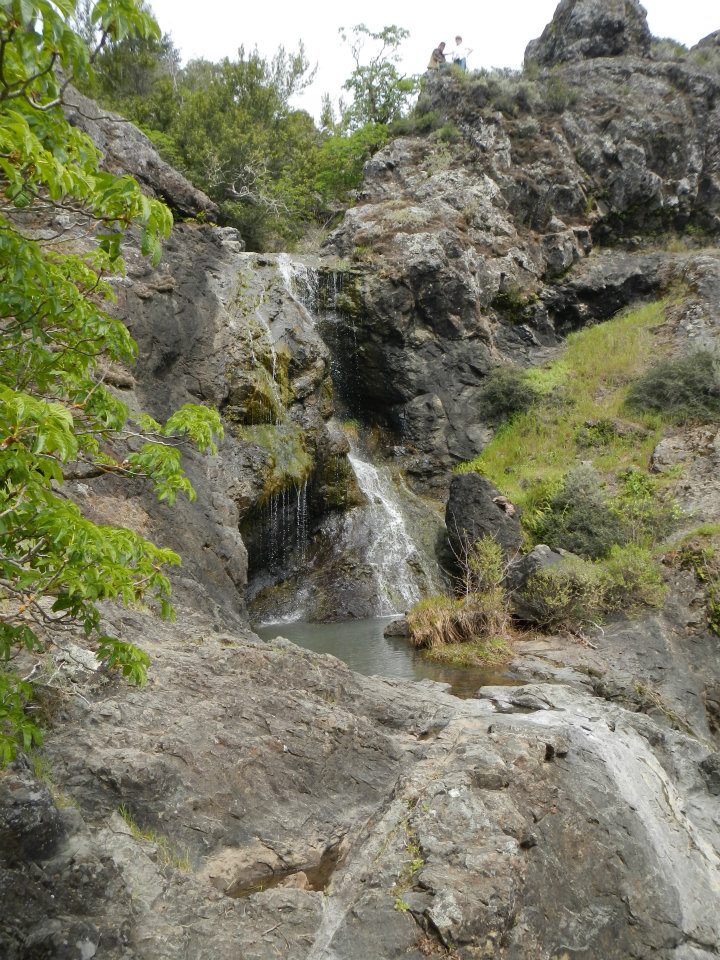
A more remote area, but still fairly popular is Little Carson Falls near Pine Mountain. Start at Azalea Hill and take Pine Mountain Fire Road to Oat Hill Fire Road. Head west on Oat Hill Fire Road and you will see Little Carson Trail starting off on the right. Follow the trail about half mile downhill to reach the falls. Continuing on the trail past the falls will take you down a steep hill towards Kent Pump Fire Road above Kent Lake. Keep a sharp eye for the Yellow Legged Frogs that call the falls home.

Photo by Craig Solin
4. Dawn Falls
Land Managing Agency: Marin County Parks
Dog Regulations: Dogs on leash at all times, unless owner and dog are on a maintained fire protection road. Dogs must be under voice control and owners must have a leash on their person at all times in order for dogs to be off leash on the fire protection road.
Difficulty: 4 out of 10
Traffic: Heavy
A kid friendly hike along a redwood lined creek, Dawn Falls is great hike for the whole family. Parking at the Madrone Drive Trail head is very limited. Some of the side streets are easier to park on. Another option is to park at the end of Crown Road in Kentfield and follow Southern Marin Line Fire Road to the top end of Dawn Falls and come in that way, but it is a steeper path then the approach from the bottom. From end to end the trail is approximately 2 miles.

5. Steep Ravine
Land Managing Agency: California State Parks: Mt Tamalpais State Park
Dog Regulations: No dogs
Difficulty: 6 out of 10
Traffic: Moderate
As the name implies the trail doesn’t have too many flat spots. It is the only trail in Marin County to feature a ladder (about 15ft tall) as part of its 1 mile length. Best access is from the Pantoll Ranger Station, which charges $8 for parking. Most people like to combine a hike on the Steep Ravine Trail with the Dipsea Trail and Old Mine Fire Road which offers spectacular coastal views on clear days.

Photo by Craig Solin
6. Waterfall Trail at Indian Valley
Land Managing Agency: Marin County Parks
Dog Regulations: Dogs on leash at all times, unless owner and dog are on a maintained fire protection road. Dogs must be under voice control and owners must have a leash on their person at all times in order for dogs to be off leash on the fire protection road.
Difficulty: 2 out of 10
Traffic: Moderate
Very easy and great hike for the whole family, follow along a seasonal creek in an Oak/ Madrone Forest. One major cascade about 10 feet tall is the center piece of the hike, but also keep a sharp eye out for lots of amphibians. Frogs, Newts, and Salamanders can be found all along the trail during and just after a rain. The trail makes a nice loop about 2 miles long with about 200 feet in elevation change. Pacheco Pond on the eastern section of the trail is a great place to stop for a picnic when the weather is clear.

Land Managing Agency: Marin County Parks
Dog Regulations: Dogs on leash at all times
Difficulty: 3 out of 10
Traffic: Light to Moderate
Cascade Creek is one of a few places left with an active Steelhead Trout run. The Steelhead are classified as endangered by the Fish and Wildlife Service. The hike back to the falls will pass right by this unique habitat and if you are observant enough you might just spot a few of the fish making their redds in the creek. Juvenile fish can be found in the upper ponds all year long. There is limited parking at both the Canyon Road and Cascade Drive trailheads. Both parallel each other from either side of the creek and run back towards the falls. Best access during high water is from Cascade Drive though, as Canyon Trail and Cascade Fire Road will be blocked by high waterflow . Both trails eventually meet with Cascade Fire Road, continue over a small hill, stay to the left at the first junction, and then cross a small wooden bridge. To get to the falls head up the trail to the right about 5 minutes to reach the falls. During the spring there is an amazing amount of wildflowers throughout the canyon.
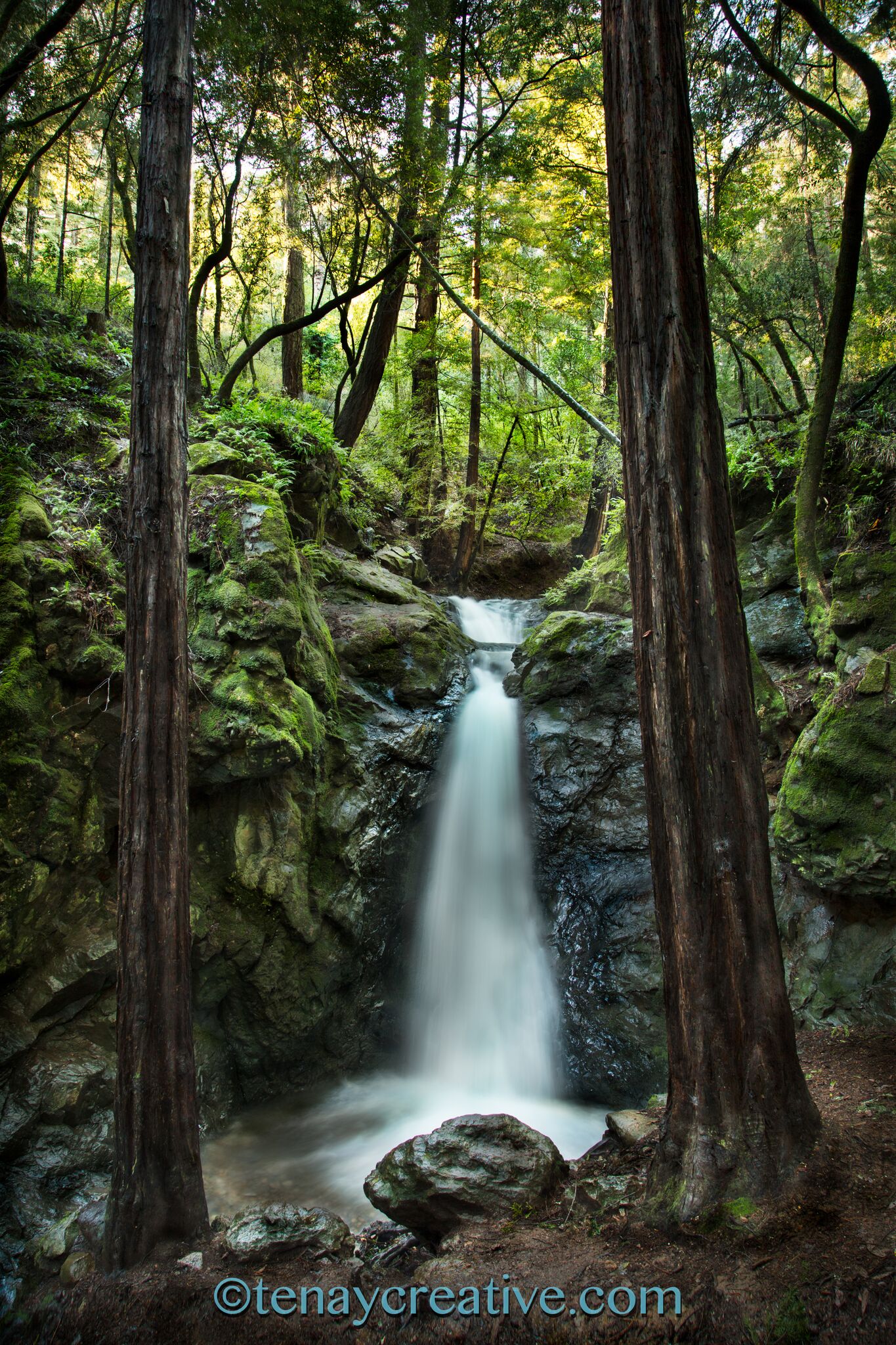
Photo By TenayCreative
8. Cascade Falls in Mill Valley
Land Managing Agency: City of Mill Valley
Dog Regulations: Dogs on leash.
Difficulty: 2 out of 10
Traffic: Moderate
Looking for a short hike near a suburban center, Cascade Falls in Mill Valley is a great visit. In about a quarter mile of hiking round trip from Cascade Drive in Mill Valley. To extend the hike go across the street and follow the city of Mill Valley Path to visit the “Three Wells”. Afterward enjoy a stroll through downtown Mill Valley.
Land Managing Agency: Marin Municipal Water District
Dog Regulations: Dogs on leash.
Difficulty: 6 out of 10
Traffic: Light
If you’re looking for an adventure, Tucker Trail is on you should consider. Best access is from Phoenix Lake trail head in Ross (Natalie Coffin Greene Park), parking can be a challenge at this location though. Heading up from Phoenix Lake head left over the damn and follow Bill Williams Fire Road along the lake to Bill Williams Trail. Gertude Ord Trail takes off to the right making a 2 mile loop of Phoenix Lake. To see some flowing water follow the Bill Williams Trail up the canyon past a few cascades, and an Old Dam that turns into a waterfall. If you were wondering who Bill Williams was, he was a lumberjack who lived in the canyon back in the late 1800s. Bill Williams Trail combines with Bill Williams shortly after passing the dam. Left will take you back to the Harry Allen Trail which leads back to Phoenix Lake and right will continue your climb up towards Eldridge Grade.

10. Fairway Falls
Land Managing Agency: Marin County Parks
Dog Regulations: Dogs on leash at all times, unless owner and dog are on a maintained fire protection road. Dogs must be under voice control and owners must have a leash on their person at all times in order for dogs to be off leash on the fire protection road.
Difficulty: 4 out of 10
Traffic: Moderate
Last of our falls, and probably the newest addition to public access is Fairway Falls in Novato. Accessed from the end of Fairway Drive in Novato go past the double iron gates at the trail head and follow the paved road as it turns into dirt. This canyon up until 15 years ago was slated to have houses built on it. At the fire road junction turn left and follow the fire road as it narrows into a trail in about a quarter of a mile you will reach the falls. The falls were originally on private property up until last April when an easement was granted to Marin County Parks for access to the falls.
Other cool “Waterfalls”
Both of these locations are not true waterfalls, but still awesome to check out if you haven’t seen them flowing.
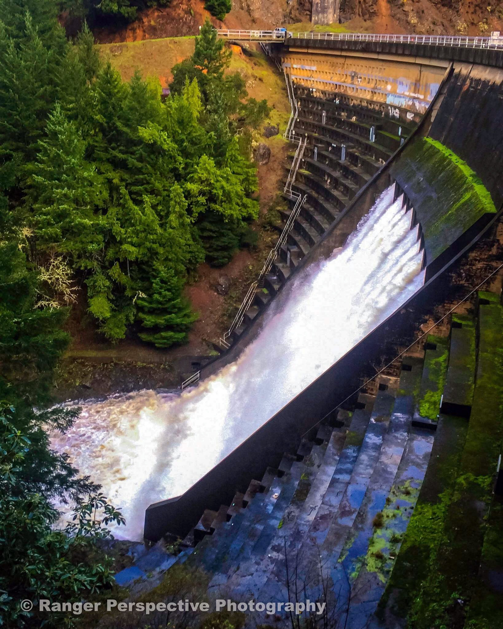
PHOTO BY MATT CERKEL
Pretty spectacular show of the power of water, Alpine Dam’s Spillway is a tunnel that goes through the middle of the dam creating a waterfall that erupts from the middle of the dam. Climbing on or going below the dam is prohibited, but you may view this from the top of the dam. The best spot is just in on Kent Fire Road which crosses a small bridge on the east side of the dam before heading out to Kent Lake. Parking is limited, but traffic is usually pretty light.

Looking for a nice easy picnic spot for the whole family the Lake Lagunitas Picnic Area is the place for you. Stay dry under the 1930s Picnic Shelter and enjoy the run off from the Lake Lagunitas Spillway as it cascades down to Bon Tempe Lake. There are lots of Amphibians and occasionally a few Great Blue Herons who hang out in the creek nearby. It is also one of a few places on Mt Tamalpais you can have a BBQ on the stoves in the picnic area. For a longer hike before or after your picnic consider hiking around Lake Lagunitas which takes about 30 minutes and is completely level. Parking is $8, access from Fairfax drive to the end of Sky Oaks Road.